Topcon IP-S3 arieal mapping & mass data collectors
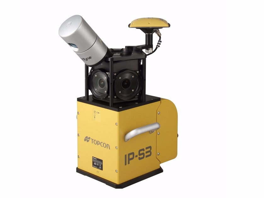
Topcon IP-S3
The IP-S3 mobile mapping solution offers high density, high precision, point clouds combined with high resolution panoramas from a system that is smaller, lighter and easier to handle. IP-S3’s positioning technology is an integration of an Inertial Measurement Unit (IMU), GNSS receiver (GPS and GLONASS) and a vehicle odometer.
The rotating LiDAR sensor captures the environment with a rate of 700,000 pulses per second. During each rotation, the 32 internal lasers cover the full 360 degrees around the system, each from a slightly different viewing angle. This minimizes gaps in the point cloud which arise from obstacles or dead-angles and removes the need to install multiple scanners.
IP-S3’s six-lens digital camera system provides 360 degree high resolution spherical images that allow for easy feature recognition.
Mobile Master Offices software handles all post processing trajectories and geo-referencing scans and images.
Features & Benefits:
- Integrated turn-key solution
- Ultra compact design
- Multiple lasers minimize scanning shades
- Unparalleled ease of use
- Factory calibrated
- Full integration of cloud and images
There is no need to conduct a field calibration which makes a very complex system of different technologies simple to use, all-together integrated and very productive.
All-in-one Mobile Master Office software includes all processing, advanced matching / ground control functions, accuracy reporting and export into various projections and geoids. With all processing steps included, workflows with the IP-S3 are significantly reduced.
Applications include:
- Mapping of Infrastructure and Assets
- Pipeline, Railways, Utility Corridors, Waterway
- Urban Planning
- Land-Use Planning
- Environmental Preservation
- Home Security
- Accident / Criminal Investigation
- Risk Management
- Road Condition Analysis
- Pre-construction, Construction Progress Monitoring
- A verity of information services for citizens and travelers.
BRIEF SPECS
| General | |
|---|---|
|
Operating Temperature
|
Range 0°C to 45°C (32°F to 113°F) |
|
Storage Temperature
|
Range -30°C to 60°C (-22°F to 140°F) |
|
Calibration
|
Topcon calibrated for high precision |
| GNSS Tracking | |
|
Number of Channels
|
226 universal channels, GPS, L1/L2, and GLONASS (1) |
| Physical and Environmental | |
|
Dimensions
|
260mm (W) x 160 mm (D) x 121 mm (H) (2) |
|
Dimensions
|
300 mm (W) x 500 mm (D) x 600 mm (H) (3) |
|
Weight
|
3.0 kg (6.6 lbs) Including sensors: 18 kg (39.6 lb) |
|
Camera Unit
|
CCD camera (6 pcs.) (4) |
| Operational | |
|
Timing Resolution
|
10 nsec |
|
Gyro Bias Stability
|
1°/hr |
|
Acceleration Bias Stability
|
7.5 mg (5) |
|
Measurement Rate
|
700,000 points/sec |
|
Range
|
100 m @ 100% reflectivity, 70 m typical (6) |
|
Maximum Resolution
|
8,000 x 4,000 pixels (7) |
| Electrical | |
|
Input Voltage
|
9V to 36V |
|
Power Consumption
|
60W |
| Performance | |
|
Continuous Surveying Time
|
8 hours (8) |
|
Surface Accuracy
|
10 mm on road surface (1 sigma) (9) |
|
Absolute Coordinates Accuracy
|
50 mm @ 10 m distance (1 sigma) (10) |
| Notes | |
|
Notes
|
(1) GNSS Receiver (2) IP-S3 timing unit (3) Sensor Unit (4) Spherical camera (5) IMU (6) Laser Scanner (7) Spherical Camera (8) (results in approx. 1 TB of data) (9) Plane fitting results on flat road surface (10) Comparison to 10 known points, 30 passes at 30 km/hr |
Partners