IP-S2 Compact + arieal mapping & mass data collectors
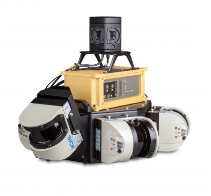
IP-S2 Compact +
The IP-S2 Compact+ system is an integration of an Inertial Measurement Unit (IMU), GNSS receiver (GPS and GLONASS) and vehicle odometry that provides precise positioning and attitude data in a dynamic moving environment. The combination of a 360 degree digital camera and laser scanning provide the user with 3D point cloud data and georeferenced imagery that can be used to extract GIS asset information. The Compact+ comes standard with 3 scanners to optimize visibility of roadside assets. The standard configuration gives a full 360 degree Vertical Field of View. An optional 5 scanner system collects 150,000 points per second at a range of 40m, with a Vertical Field of View of 360 degrees.
Topcon's powerful software will post-process the georeferenced LiDAR and/or digital imagery data into a viewable 3D image representation which can then be exported to industry standard formats. GNSS data can be post-processed against a reference station for higher accuracy. Optional software is available for a variety of applications such as:
Roadway Asset Management, DTM and Contouring, Mining, Utilities, Volumes, Power Transmission and Distribution and others.
Integrated High Density Mobile Mapping System
Features & Benefits:
- 3D LiDAR Scanning of Roadside Features
- High accuracy IMU options without export control
- Capture Geo-referenced, Time-Stamped, Point Clouds and Imagery
- 360° Camera for Spherical Image Capture
- Simple Map, Extract, Deliver Workflow
- Integrated Turn-key Solution
BRIEF SPECS
|
Channels
|
40 channels, dual constellation, dual frequency GPS+GLONASS L1/L2 |
|
Low Signal Tracking
|
Down to 30 dBHz |
|
Reacquisition
|
< 1 sec |
|
Real-time Position and Raw Data
|
Up to 10 Hz update rate |
| IMU (Commercial Grade option, High accuracy IMU) | |
|---|---|
|
Gyro type
|
Fiber Optic Gyro |
|
Gyro Bias Stability
|
1°/hr |
| Power | |
|
Input Supply Voltage
|
Continuous 12-14 VDC with approximately 50 amp draw |
| Physical | |
|
Size
|
1422 x 699 x 1245mm |
|
Weight
|
approx 86 lbs (39kg) |
| Environmental | |
|
Operating Temperature
|
-10° to +40°C |
| Panoramic Imagery Component | |
|
Imaging Sensor
|
Six Sony progressive scan color CCDs (five in the horizontal ring, one on top) |
|
Maximum Panorama Resolution
|
5400 (H) x 2700 (V) |
|
Field of View
|
>80% of full sphere, 360 degree Panorama |
| LiDAR Components | |
|
System Field of View
|
360 degree Vertical Field of View, X-configuration when using 5 scanner option |
|
Field of View per scanner
|
190° max |
|
Scanning Frequency
|
75 Hz | 100 Hz |
|
Operating Range
|
0.7 m......80 m |
|
Laser Class
|
1, eye-safe (IEC 60825-1 (2007-6)) |
|
Angular Resolution
|
0.5 degree | 0.667 degree |
|
Imaging Sensor
|
Six (6) ICX204AQ 1/3” 1024x768 progressive scan CCDs |
|
Data Output
|
15 FPS uncompressed 8bpp Bayer-tiled data 30 FPS JPEG compressed 8bpp Bayer-tiled data |
|
Frame Rates
|
30, 15, 7.5, 3.75 FPS |
|
Optics
|
Six (6) 2.5mm focal length high quality micro lenses |
|
Gain
|
Automatic/Manual Gain modes, 0 to 26dB |
|
Shutter
|
Automatic/Manual Shutter modes, 0.06ms to 33.3ms @ 30 FPS |
|
Resolution
|
4.7 megapixels |
Partners